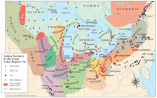
The Detroit Potawatomi left their villages on the Detroit River in October 1763 and spread their villages to the south and west, setting up various hunting camps.
In 1765, they established several villages on the Huron River and, at that time, became known as “Potawatomi of the Huron” (Summary Under the Criteria and Evidence for Proposed Finding Huron Potawatomi, Inc., 1995, p. 39)
The departure of the Potawatomi from Detroit can be confirmed:
in a deed dated May 26th, 1771, ratified July 15, 1772, in which the tribal chiefs of the nation of Potawatomi at Detroit granted to Robert Navarre a tract of land, four arpents by the entire depth, situated at the Potawatomis “ancient village” “forever so he may take care of our dead.” General Gage later confirmed this deed (Summary Under the Criteria and Evidence for Proposed Finding Huron Potawatomi, Inc., 1995, p. 53).
By 1774, the Potawatomi of the Huron established another village on the Salt Fork of the River Raisin (Edmunds, 1978, p.99). They called this village “Naudewine Sippy” or “Waudagon Sippy” (which were variants of “Nottawasepi”). They also set up villages on the Grand River near modern-day Eaton Rapids (Edmunds, 1978, p.99).
By 1800, the Potawatomi “bands” identified circa 1700 had transformed due to the movement of the tribes; they evolved into the following broad groups (Sultzman, 1998, p. 3):
- The “Potawatomi of the Woods” of southern Michigan and northern Indiana
- The “Forest Potawatomi” of northern Wisconsin and Upper Michigan
- The “Potawatomi of the Prairie” of northern Illinois and southern Wisconsin
It is essential to highlight that, “in 1800, the Potawatomi still constituted a single [emphasis added] tribal organization. Even though it was (and has been) a common practice for some to apply the word ‘band’ to the various regional coalitions of Potawatomi villages,” the evidence does not point to the Potawatomi themselves following that line of thought (Summary Under the Criteria and Evidence for Proposed Finding Huron Potawatomi, Inc., 1995, p. 58).
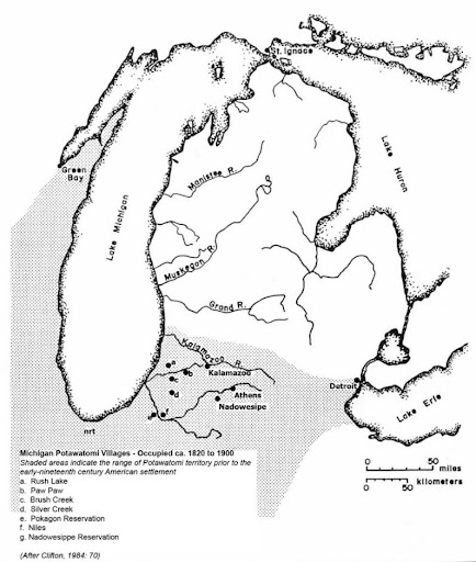
The Potawatomis’ enduring and most significant “political-geographic unit was the village, of which there were more than 100” by 1800. Villages were typically named after a particular geographic feature, such as “Silver Creek,” “Rush Lake,” or “Nadowesippe Reservation” (Summary Under the Criteria and Evidence for Proposed Finding Huron Potawatomi, Inc., 1995, p. 59).
By 1820, numerous Potawatomi villages, including “Nadowesippe” (a.k.a., Nottawaseppi), were spread throughout eastern Wisconsin, southern lower Michigan, and northern Indiana and Illinois; in total, this amounted to roughly 28 million acres.

References:
Clifton, J., Cornell, G., & McClurken, J. (1986). People of the Three Fires: The Ottawa, Potawatomi, and Ojibway of Michigan. The Michigan Indian Press.
Edmunds, R. D. (1978). The Potawatomis: Keepers of the Fire. University of Oklahoma Press.
Swanston, M., & Swanston, A. (n.d.). Indian Territory in the Great Lakes Region 1768 [Map]. Swanston Map Archive Limited.
Sultzman, L. (1998). Potawatomi History. Retrieved from http://www.tolatsga.org/pota.html
Summary Under the Criteria and Evidence for Proposed Finding Huron Potawatomi, Inc. (1995). United States Department of the Interior Bureau of Indian Affairs Branch of Acknowledgement and Research. https://www.bia.gov/sites/bia.gov/files/assets/as-ia/ofa/petition/009_hurpot_MI/009_pf.pdf

